

Introduction
The southern part of Philippines experienced panic and fear during the early hours of Monday after being hit by a destructive 7.8 magnitude earthquake that caused the collapse of structures, caused landslides, and even caused tsunami waves to pound the coasts of the area. This destructive earthquake that has caused many deaths in the area is among the most powerful to have happened recently.
The Earthquake Hits
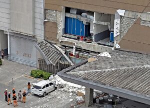
The magnitude 7.8 earthquake occurred around 7:37 a.m. local time (2:37 p.m. IST) in the waters roughly 32 kilometers southwest of Asim in Sarangani province, Mindanao Island. According to USGS, the source depth of the earthquake was between 33 and 35 kilometers, which made it especially devastating for structures above ground.
The earthquake shook violently for several horrific minutes, forcing people to evacuate from buildings due to falling walls and debris. Buildings were destroyed in General Santos City, including the Mahayahay Elementary School.
Tsunami Warning and Coastal Effect
Tsunami warnings were raised almost immediately after the earthquake hit the area. According to reports from the Philippine government, there were 3 feet (1 meter) of tsunami waves hitting the coastal regions, with the highest at 1.4 meters (4.6 feet) in Kiamba town.
People were advised to evacuate their homes on the coast immediately. Tsunami danger ended around five hours after the earthquake, but the danger was not completely out of their minds yet.
Human Toll and Damage
The disaster has claimed a devastating number of lives:
Aftershocks and Persistent Dangers
There have been several aftershocks, some even as large as 6.5 on the Richter scale. The geologists in the area warn that the region is still prone to more earthquakes, causing further evacuation of the area.

Governments’ Responses
The government of the Philippines has put affected provinces on a state of emergency. All schools in Mindanao have been shut down while search-and-rescue teams are being sent out in search of survivors. Several international humanitarian organizations are following the developments and some are even willing to offer help to those affected.
This Is Not the First Earthquake of the Year
This fatal incident does not refer to the 7.4 magnitude earthquake that struck the Philippines in October 2025 and resulted in fatalities ranging from 1 to 6 people. This is yet another disaster that occurred recently.
Conclusion
The aftermath of the magnitude 7.8 earthquake is that the southern region of the Philippines has been shocked. There are piles of debris in the towns and cities as well as people grieving for their deceased family members. The country faces the tragic situation of experiencing yet another natural disaster. It may take some time to get an idea of the total damage caused by the earthquake, but those few terrible moments will be imprinted in people’s memories forever.